
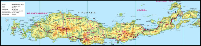
The map here above is not updated (as there are 8 regencies and not 6; Nagekeo and Manggarai Timur are missing) but may give you an idea of the island.
From east to west the island is 355 kilometers, via the road from Larantuka to Labuan Bajo around 660 kilometers.
Need a good map of Flores?
Flores Travel Map, ISBN 978-3-9523834-4-5
The most complete map of Flores (2012) with maps of the small towns and some trekking areas. Rp 80.000, available on Flores and at the airports of Jakarta, Bali and Labuan Bajo.
WHEN?
The driest months are May to October when it is supposed to be not too rainy. However a shower now and then keeps Flores green and clean.
The rains sometimes start in November, sometimes in December with the peak in January, February and March. Heavy and long showers can cause floods and sometimes landslides and potholes as the
drainage system is not adequate enough. Trekkings are more difficult or even not possible at all and the sea between Labuan Bajo and Sumbawa and off the south coast can be rough and boats
sometimes are not allowed to sail.
However these days the weather is more and more hard to predict like elsewhere in the world. Rain is often late and when it comes there is extreme weather with amounts water which the rivers
can't handle. Therefore many landslides, broken bridges, houses washed away and unfortunately also many (sometimes deadly) victims.
In January 2016 the mountains around on the west coast and on the islands off the coast of Labuan Bajo hardly turned back to green again due to (too) little rain. But in June and July 2022 Flores was far much greener than in other years, as was November in the same year. Due
to more and sometimes heavy rainfall. In August 2022 the temperature in Maumere even dropped to 24C only on the middle of the day.
In 2023 El Niňo arrived and the rains didn't start before February 2024. Crops failed and prices for rice went sky high and many farmers had (and still
have) a hard time.
Flores has microclimates so the weather can be totally different on places not even that far from eachother.
When you are planning an overland trip take 1 or 2 sweaters with you. Places like Bajawa, Ruteng and Moni can be very cold at night in particular in the dry months!
Most tourists visit Flores in the months July and August. November to March is low season.
WHERE AND WHAT?
Highlights on the island are Kelimutu Lake, Komodo National Park, the adat villages around Bajawa, Wae Rebo, Riung Marine park 17 islands and diving and snorkelling. Flores is not yet as famous as parts of Kalimantan and Sumatera when it comes to (volcano) trekking but it is definitely competitive with other islands. And, the nature on Flores is a highlight itself.
People come to Flores for:
- Kelimutu lakes
- traditional villages
- diving & snorkeling
- komodo dragons
- traditional villages and ceremonies
- unspoilt beaches
- volcanos for hiking
See also the separate regencies
and
and
routes
HOW?
You can travel by plane (but you will miss the beauty of the island).
Or by bus together with the locals and everything they carry including chickens, freezers, huge baskets with eggs, a new mattress they bought in town and everything one can imagine.
Or by travel, a kind of shared taxi, mostly a big car or a minibus, a bit more expensive than the bus but more comfortable and faster.
Or you can hire a car with driver so you can stop whenever you want to. As a foreigner you cannot drive a car yourself as there are no rentals that offer this service.
See all kinds of transportation in the regencysections of East Flores, Central Flores or West Flores and the special about transportation on Flores.
HOW LONG?
Let me tell you first that Flores deserves more than a 3 or 4 day trip to Labuan Bajo for diving and see the komodo dragons by chance. Flores has a diversity of attractions.
If you only visit Labuan Bajo for Komodo National Park and diving/snorkeling a few days will be enough, but you will miss the
wonderful interior. Said that while Labuan Bajo has become more and more touristy, heading east you will have Flores mostly for yourself. If travelling overland the classic tour starts in Maumere
and ends in Labuan Bajo and will be at least 6 to 8 days. More comfortable are 10 to 14 days with the possibility to start in Larantuka (maybe
even a sidetrip to Solor or Adonara) a region seldom visited by tourists and you can travel via alternative routes
via the north. Three to four weeks will give you the most complete impression of Flores.
Read also this section for routes.
THINGS TO SEE AND DO FROM EAST TO WEST
Below a (probably not complete) list of see's and do's all over the island from east to west.
Note:
Not all attractions or activities can be done in one holiday or within the usual limited time as some places are remote and require a lot of time to get there (yes, even if they seem very close on the map). Some roads are still in very poor condition. The average speed on the main road is around 35 kilometers/hour, but on small roads or even paths this sometimes is only 10 to 15 kilometers/hour. Also don't be fooled by Google Maps as this is often not the reality except maybe the main road, the Trans Flores (but only if in ideal condition without obstruction on the road).
So please make a choice what you want to see and do.
See also this part
Larantuka and surroundings
- Beach Ina Burak, Adonara
- Beach Kawaliwu, also for sunset (good combination with Ile Padung)
- Beach Kwuta, 6 kilometers (1 hour!) west from lake Asmara
- Beach Lato, 20 kms west of Kawaliwu
- Beach Mekko, Adonara
- Beach Nobo
- Beach Oa near Lewotobi (surfing)
- Beach Rako near Lewotobi (surfing)
- Beach Watohari, Solor
- Beach Watotena, Adonara
- Biara Trappist monastry in Tanjung Bunga
- Cathedral Rheina Rosari
- Catholic graveyard just outside Larantuka (seaside)
- Chapel Tuan Ana
- Chapel Tuan Ma
- Chapel Tuan Meninu
- Coastline Nobo to Larantuka with views on Adonara, Solor and Konga
- Detour Nobo to Boru around the twin volcanos Lewotobi Laki2 and Perempuan
- Diving and snorkling near Wureh
- Ile Padung, traditional village of Flores Timur
- Market Larantuka
- Mater Dolorosa
- Mount Lewotobi twin volcano near Boru, East Flores (start at Bawalatang)
- Lake Asmara, a beautiful lake to be reached via a path through dense forest
- Larantuka King's Palace (history 1st Catholic kingdom of Indonesia)
- Lewokluok, weaving village; every Thursday or on request
- Leworook coffee plantation (not far from Lewokluok village)
- Riangkeme near ile Mandiri (tenun ikat)
- Roundtrip ile Mandiri
- Taman Bukit Fatima, Larantuka
- Tanjung Bunga, the "tail" of Flores with a rich history
- Trekking ile Mandiri
- Trekking ile Lewotobi (twin volcano)
- Trip to Adonara island on a daytrip by boat or 1 to 3 days (Watotena Beach, Mekko
Beach, Ile Boleng)
- Trip to Solor island, on a daytrip by boat or 1 to 2 days (Lamakera, whales,
Portugues fortress in Lohayong, pantai Watohari, beaches in the southern
part.
A wooden boat leaves from Larantuka at 9 am and back from Podor at 16:00 hrs
- Tunaboats south of Larantuka
- Semana Santa (from Wednesday before Eastern until Saturday including Good
Friday) bookings for Semana Santa need to be made at least 6 months before
- Sunset Kajuwulu, north west of Larantuka
- Waibao, Tanjung Bunga (tenun ikat)
Larantuka
Between Larantuka and Maumere
Trans Flores road in good condition, other roads not all so good
- Bantala, west of Larantuka (tenun ikat)
- Beach Doreng, via a partly potholed road
- Beach Lato, 20 kms
- Beach Likutuden
- Beach Nobo
- Beach Oa near Lewotobi (surfing)
- Beach Rako near Lewotobi (surfing)
- Bola, weaving village (tenun ikat)
- Coastline Nobo to Larantuka with views on Adonara, Solor and Konga
- Daytrip to Pulau Besar, Koja Doi and Pangabatang island (boats from Nangahale)
- Detour Nobo to Boru around the twin volcanos Lewotobi Laki2 and Perempuan
- Diving and snorkling near Maumere and the islands north of Waigete (Babi island,
Pulau Besar), around 30 kms from Maumere check this diving website
- Dokar, weaving village
- Ile Padung (traditional house)
- Lewokluok, weaving village; every Thursday or on request, no activities on Sunday
- Mount Egon near Maumere
- Leworook coffee plantation (not far from Lewokluok village)
- Tanjung Ogor Paret
- Trekking ile Lewotobi (twin volcano)
- Sikka old church and weaving village
- Watublapi, weaving village
Adonara & Solor
- Ile Boleng volcano on Adonara
- Ina Burak Beach on Adonara
- Kampung Adonara & lake
- Lamakera, whales
- Mekko Beach, Adonara
- Pantai Riang Sunge, beach on Solor
- Pantai Watohari, beach on Solor
- Pantai Wewa, beach on Solor
- Portugues fortress in Lohayong, Solor
- Watotena Beach on Adonara
Maumere and daytrips from Maumere
- Alok Market
- Beach Doreng, via a partly potholed road
- Boattrip Pulau Besar, Pulau Koja Doi and Pangabatang
- Bukit Liaga, chartered boat from the beach beyond lake Tiwu Bowu
- Bukit Salib Kolisia, a wonderful viewpoint west of Maumere
- Cathedral St. Yosef, Maumere
- Daytrip to Pulau Besar and Koja Doi which is connected by a small stone foothpath
and Pangabatang island (boats leave from Nangahale)
- Diving and snorkling near Maumere and the islands north of Waigete (Babi island,
Pulau Besar), around 30 kms from Maumere. Check this diving website
- Dokar, weaving village
- Doreng Beach
- Lepo Lorun, weaving village
- Mount Egon volcano climbing
- Nilo, hill with statue of Mother Maria with views on Maumere
- Ricefields near Magepanda (months January-June)
- River landscape beyond Kotabaru
- Sikka, old church and weaving
- Tiwu Bowu lake and beach with fishermen a few hundred meters beyond
- Wair Nokerua, a beautiful coastline and for sunset
- Watublapi, weaving village
- Wuring, muslim village on stilts, 4 kms from Maumere (unfortunately also a lot of
plastic these days)

Tenun ikat Sikka
Maumere to Moni
Trans Flores road in good condition
- Cocoa plantation
- Koka Beach, the most beautiful beach on Flores, also for camping
- Lepo Lorun weaving village
- Nilo hill with statue of Mother Maria with views on Maumere
- Paga Beach
- Sikka, old church and weaving
- Wuring, muslim village on stilts (unfortunately also a lot of plastic these days)
Koka beach
Maumere to Moni via Maurole, north coast
with some adventurous stretches
- Adventurous coastline :-)
- Bukit Liaga, a "mini Padar" to be reached by boat from the beach near Tiwu Bowu
- Bukit Salib Kolisia, a wonderful viewpoint west of Maumere
- Enabara beach
- Murumite waterfall
- Ricefields near Detusoko
- Ricefields near Magepanda (months December-August)
- River landscape beyond Kotabaru
- Tiwu Bowu lake and beach with fishermen a few hundred meters beyond
- Wair Nokerua, a beautiful coastline also for sunset
- Wologai traditional village
- Wuring, muslim village on stilts (unfortunately also a lot of plastic these days)
near Magepanda
Moni
- Jopu Ranggase traditional house
- Kelimutu NP, the three coloured lakes (13 kilometers from Moni, good road)
- Nggela, traditional village
- Trekking downhill Kelimutu to Moni
- Waterfall Murandao
- Waterfall Muru Dhaekale
- Waturaka village
- Wologai traditional village
- Wolopaku coffee plantation
Moni to Ende
Trans Flores road in good condition
- Bamboo bridges
- Coloured hanging bridge
- Detusoko ricefields
- Market Ende
- Market Wolowona
- Rock with mark Floresweg (Trans Flores Road, made by the Dutch in 1925)
- Saga traditional village
- Sunset from Puncak Ndona
- Sunset from Pantai Kota Raja
- Waterfall Murandao
- Waterfall Muru Dhaekale
- Wologai, traditional village
- Wolopaku, coffeeplantation
Ende and daytrips from Ende
- Cathedral Kristus Raja Ende
- Coastline east of Ende
- Former house & museum of Soekarno, the 1st president of Indonesia
- Iya volcano, climbing for sunrise or sunset
- Market Ende
- Market Wolowona
- Nanganesa black sand beach, east of Ende
- Memorial Pancasila, the 5 principles of Indonesia
- Pantai Kota Raja, boulevard and sunset (grilled fish at the seaside)
- Kedebodu waterfall, Ende
- Sunset from Puncak Ndona
- Sunset from Pantai Kota Raja
- Wolotopo traditional village
Ende to Bajawa
Trans Flores road in good condition
- Coastline Ende to Nangaroro
- Market Boawae on Wednesday
- Market Ende
- Mengeruda hotspring, Soa (when via the
detour Boawae to Bajawa via soa)
- Mount Ebulobo, 2124 MASL, Mulakoli is the startingpoint
- Padhawatu waterfall
- Penggajawa, blue stone beach near Nangapanda also nice for lunch
- Turetogo bamboo village
- Wogo, traditional village Ngada
- Wolobobo, hill with view on mount Inerie; alsof or sunset
Moke, the traditional spirit on Flores
Ende to Mbay via Aegela
road in good condition
- Coastline Ende to Nangaroro
- Market Ende
- Penggajawa, blue stone beach near Nangapanda also nice for lunch
- Kawa traditional village
- Great views on the valley, 8 kms before Mbay
South Coast Nagekeo
some roads in poor condition
- Coast around Mauponggo
- Tonggo beach
- Wajo traditional village

Ricefields in Nagekeo
Mbay and daytrips from Mbay
- Japanese caves
- Kotajogo Beach
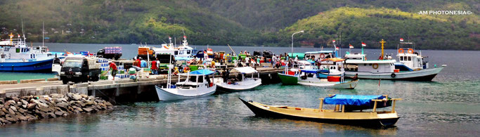
- Marapokot harbour
- Rii Taa island (1 hour from the harbour)
- Ricefields north of Mbay and the 7 palmtrees (also nice for sunset)
- Riung Marine National Park 17 islands
- Tutubhada traditional village
- Wewo Dhacatung and Wewo Rowet, two strange but beautiful shaped hills
Mbay to Riung
repaired road
- Nggolonio traditional village
- Rii Taa island (1 hour from the harbour)
- Scenic road Mbay to Riung
- Wewo Dhacatung and Wewo Rowet, two strange but beautiful shaped hills
Bajawa to Mbay via Boawae
with a few bad stretches
- Batu kodok, a huge frog shaped stone
- Jalan tengah, a beautiful road with views on mount Ebulobo
- Mengeruda hotspring near Soa
- Tutubhada, traditional village
- Wogo, traditional village
- Wolobobo hill with view on mount Inerie and sunset
Riung and daytrips from Riung
- Riung Marine Park 17 islands and camping on one of the islands
- Two bulky trees on both sides of the road; a car barely fits
- Watu Mitong (also for sunset)
Riung to Bajawa
Since 2021 the road is ok and now only takes 2 to 2,5 hours.
- Mengeruda hotsprings near Soa
- Yayasan Puge Figo
Riung to Reo
road has been improved since 2022
- Bukit Nanga Lok, viewpoint between Riung and Pota
- Bukit Watumeze
- Coastline near Pota
- Mountains
- Rana Tonjong (lotus lake) near Pota
- Reo river
- Ricefields
- Riverlandscapes
- Sunset in Dampek, east of Reo
- Watu Mitong also for sunset
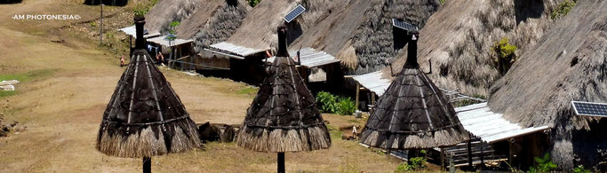
Bajawa and around
most roads are small but in good condition
- Arrack production in Aimere
- Bobou market Bajawa
- Coffee plantations
- Hike downhill from Belaraghi to Paukate
- Hike from Bena to Tololela through the bamboo forest (and on to Gurusina)
- Malanage hotspring near Bena
- Manulalu viewpoint
- Mengeruda hotspring near Soa, also camping
- Mount Inerie volcano climbing, 2245 MASL (dep 2 am, return between 10 and 12 am)
- Mount Inerie volcano climbing 2245 MASL 2 days including camping
- Ogi waterfall (less water in the dry months August to October)
- Statue Mother Maria in the mountains and view on the valley
- Traditional villages
Bela
Belaraghi (overnight possible), also trekking possible
Bena (overnight possible), trekking from Bena to Tololela and on
to Gurusina
Gurusina, trekking from Bena to Tololela and on to
Gurusina
Langa
Luba
Maghilewa (overnight possible)
Tololela (overnight possible), trekking from Bena to Tololela and on to Gurusina
Wogo
- Trekking to Belaraghi, traditional village of Ngada, 7 - 9 hours possibility to overnight
- Tenun ikat, woven cloth with natural materials
- Valley north east of Bajawa
- Watu Nariwowo, acces near Langa with view on Inerie and environment
- Wawo Muda, brown red coloured lake on a hill
- Wolobobo hill, view on mount Inerie and sunset
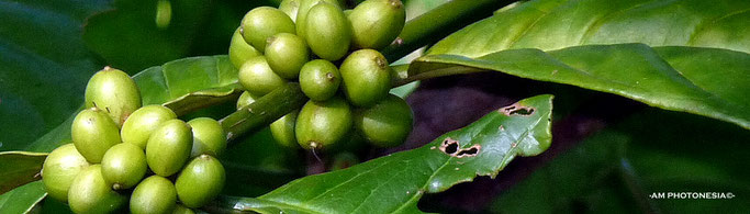
Bajawa coffee
Bajawa to Ruteng
Trans Flores road in good condition
- Arrack production in Aimere
- Belaraghi, traditional village Ngada, by car 20 minutes from the mainroad in Aimere
- Countryside east from Ruteng (views, forest, ricefields, villages)
- Danau Ranamese (lake)
- Hike downhill from Belaraghi to Paukate
- Market Ruteng
- Mbalata beach, also camping
- Watu Cepi Beach
Belaraghi village
Ruteng and daytrips from Ruteng
- Cancar, spiderweb ricefields and camping, entrancefee Rp 15.000 to Rp 20.000
- Cathedral Ruteng
- Countryside around Ruteng (views, forest, ricefields, villages)
-
Detour around the valley near Cancar with acces to the mainroad
- Danau Ranamese
- Golo Curu hill and view over Ruteng
- Ketebe beach west of Reo
- Liang Bua cave; site of homo floresiensis (45 minutes drive from town)
- Market Ruteng
- Pangkadari waterfall
- Road Ruteng Reo vv, Reo river
- Road Ruteng Iteng vv
- Ruteng Pu'u traditional village
- Tengkulese waterfall

Weaving cloth north of Ruteng
Ruteng to Iteng
also alternative road to Dintor and Wae Rebo; bad, potholed road
Take the road between the two huge mountains and continue through dense forest
(national park) and fine views over ricefields all the way to Iteng.
This is also an alternative road to reach Denge/Wae Rebo; however parts are in bad shape with mud and potholes. There is a new road to the west just a
few kilometers before Iteng. The alternative is the classic route via Todo. Travelingtime is the same.
Reo to Lemarang
road in good
condition
Beaches near Robek, pantai Ketebe, also camping. It is not possible to continue westwards to Terang and Labuan Bajo as the bridge has been collapsed (May 2018)

West of Reo
Ruteng to Wae Rebo
beyond Todo road with bad stretches
- Cancar, spiderweb ricefields and camping, entrancefee Rp 15.000 to Rp 20.000
- Countryside west from Ruteng (views, forest, ricefields, villages)
- Todo, traditional village of Manggarai
- Wae Rebo, the icon of the traditional villages of Manggarai with trekking 3 to 5
hours uphill and 1,5 to 3 hours downhill; startingpoint is in Denge
Ruteng to Labuan Bajo
Trans Flores road in good condition
- Cancar, spiderweb ricefields and camping, entrancefee Rp 15.000 to Rp 20.000
- Cunca Plias, on the road to Cunca Rami
- Cunca Rami, waterfall, but best visited from Labuan Bajo on a day trip
- Cunca Wulang, waterfall and canyon, including a short hike, entrancefee Rp 50.000
pp plus guide Rp 50.00 per group
- Detour around the valley near Cancar with acces to the mainroad
- Lembor ricebarn
- Nangalili Beach, 40 minutes off the mainroad near Lembor
- Ruteng Pu'u traditional village
- Toda, (not Todo but Toda) traditional village of Manggarai Barat
- Todo villages, entrancefee Rp 60.000 for foreigners
- Sanggoang lake, but best visited from Labuan Bajo
- Spiderweb ricefield near Toda
- Spiderweb ricefields near Ketang
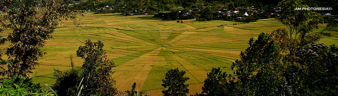
Cancar spiderweg ricefields
Labuan Bajo and daytrips from Labuan Bajo
- Batu Cermin cave
- Cunca Rami waterfall (good combination with Sano Nggoang lake)
- Cunca Wulang, waterfall and canyon, including a short hike, entrancefee Rp 50.000
pp plus guide Rp 50.00 per group
- Islands west and north of Labuan Bajo like Bidadari, Menjerite, Kelor etc.
- Kaca for petrified wood
- Kalong island (the bat island with flying foxes)
- Kelor island
- Komodo National Park (komododragons, diving and
snorkling)
- Manta Point (Tata Makassar), Komodo NP
- Melo, east of Labuan Bajo views over Komodo National Park (sunset!)
- Menjerite island
- Mount Mbeliling (trekking, bird watching)
- Padar Island for the magnificient view
- Pantai Pede (beach southern part of Labuan Bajo)
- Pink Beach
- Pulau Komodo, for the komodo dragons
- Pulau Padar with the magnificent view
- Pulau Rinca, for the komodo dragons
- Puncak Waringin, viewpoint in Labuan Bajo
- Rangko Cave, north of Labuan Bajo (15 minutes by boat from Rangko)
- Road to Golomori
- Sano Nggoang lake (accomodation available) but bad road
- Sunset from Paradise Bar, Pede Beach or Bukit Cinta
- Tata Makassar
- Terang for nice views
- Tobedo, for petrified wood
- Waecicu beach, also camping
- Warloka fishing village, only 30 minutes south of Labuan Bajo
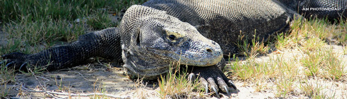
komodo dragon on Rinca
Across the island
- bambu forests
- candlenut trees
- cashew nut trees
- clove trees
- cocoa plantations
- coffee plantations
- lontar trees for arrack production
- vanilla
- and above all friendly people....
Visiting Komodo National Park
Labuan Bajo has dozens of agents, small offices and people on the road offering trips to Komodo NP. However the business isn't transparant and not all agents are serious about safety.
ROUTES & TRAVEL SUGGESTIONS
When you need help with finding a car with driver please leave a message with
-dates
-booked flights
-global planning (if there is already one)
-your interests
-how many people, also adults/children (important when needing a car)
-the amount of luggage
The more I know, the better I can help you. Your email will be answered within 48 hours. Contact.
Denpasar (Bali), Jakarta, or Kupang (Timor) are the most convenient airports to start your trip to Flores. If you want to combine your holiday with South Sulawesi, Sumba, Timor or Alor there are also connections with airports on Flores (check the transport section).
SELAMAT JALAN!
HAVE A NICE TRIP!
Anne Mieke -AM PHOTONESIA©-